Reaching Resilience: Climate Services for Gulf of Maine Communities
Perspectives | Apr 11, 2024
What resilience looks like in Portland might be different than what it looks like in Tremont, but our Climate Center team provides cities and towns along the coast with services that help them reach a version of resilience that is community-driven and grounded in the best available science.

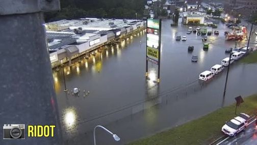
Anyone who lives in Maine or follows the news knows that sea-level rise is driving more frequent and widespread coastal flooding along Maine’s ~5,400 miles of tidally-influenced coastline, and communities are searching for ways to adapt. This year, we've already seen coastal flooding sweep away fishing houses and wharves that have stood for more than a century. Families who live on the coast have watched their yards literally erode into the sea. Ecologically important dune habitat has suffered irreparable damage as a result of coastal flooding.
In the face of these threats, many are asking, “How can we make these communities more resilient?”
While resilience is a somewhat abstract concept, the impacts we’re seeing here are painfully concrete. In broad terms, coastal resilience can be defined as the ability to prevent a short-term hazard event from turning into a long-term, community-wide disaster. What that actually looks like in practice, though, might not be as readily apparent and depends on local social, economic, and ecological characteristics.
Assessing vulnerabilities
Communities and businesses looking to build resilience to climate impacts are generally looking for answers in the form of single numbers. How high do electronics on wharves need to be to avoid getting damaged in high water events? How many times a year will my basement flood?

Finding those hyperlocal numbers isn’t easy. Water level information is more readily available at a regional scale, and for changes in average conditions. For example, we know that by 2050, the Gulf of Maine sea level is projected to rise by as much as 1.5 ft above 2000 levels. Information at the local scale, under extreme conditions (e.g., Union Wharf in Portland, Maine will see water levels at X height during a once in 100-year storm), is harder to come by. Significant year-to-year variability due to natural fluctuations in tides and water levels further complicates things.
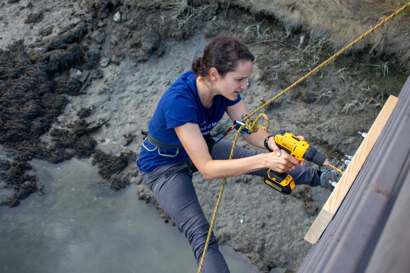
Tide gauges are one tool that make it possible to collect local water level and flood impact data, but Maine’s coast has sparse tide gauge coverage. Through a project supported by the National Science Foundation’s CIVIC Innovation Challenge, GMRI Coastal Scientist Dr. Hannah Baranes and her team are increasing tide gauge coverage along Maine's coast by installing Hohonu water level monitors in Machias, Saint George, Boothbay Harbor, and Portland.

Once Hannah has concrete water level data, she works with other members of the Climate Center team to gather community observations during high water events. Community engagement is critical, because numbers alone are not as useful to municipal decision-makers as numbers combined with visual examples of impact. This combination of quantitative and qualitative data collection boosts the availability of localized extreme water level information for both short-term preparedness and long-term planning.
Surfacing values and identities
Once we have a clearer understanding of what a given water level means for flooding impacts in specific localities, we work with waterfront owners, business owners, town leaders, and engaged community members to learn more about their concerns, what they value, and, ultimately, what actions to prioritize.
These discussions provide community members with a safe space to talk about a topic that can induce confusion and anxiety. The uncertainty introduced by a changing climate means the past is no longer a good predictor of the future. The experience of planning for that future can be unsettling, as it disrupts our sense of place in a home we cherish. Our Climate Engagement Specialist Steph Sun helps lead these tough discussions with towns across coastal Maine, from Kittery to Lubec. She begins discussions by asking community members to reflect on what the waterfront used to look like in the past, versus what it looks like now.
This highlights that change over time is a constant, and that change can be hopeful when it is grounded in community values. Our shared history and values are an inspiring and motivating place to begin the process of planning for the future.
![This is the staff photo of Stephanie Sun]() Stephanie Sun Program Manager Community Climate Action
Stephanie Sun Program Manager Community Climate Action
All of this information, from tide gauge data to the surfacing of community values and sense of place, gets included in something called a Climate Vulnerability Assessment, a product we recently completed for the coastal town of Tremont. These vulnerability assessments highlight risk levels for important infrastructure, recommended actions, and town priorities — all informed by local data and community values.
As towns seek to integrate local climate data and community values into their existing decision-making processes, involving municipal decision-makers in these discussions adds even more value. Community members are concerned and ready to see their communities tackle climate planning and action, especially after recent storms exposed vulnerabilities. Recently, we convened Portland’s working waterfront owners and municipal decision-makers to share observations from the devastating January storms and discuss plans for adapting to future high-water events.
The recent storms provide a real-time opportunity to address challenges as they happen. Some wharves came through better than others. We need to build on success and work to avoid failures. Anytime coastal property owners convene around objective realities of storm damage, there's an opportunity for mutual learning outside of the political conversations that can cloud the search for solutions.
Bill Needelman Portland Waterfront Coordinator


Ruth Hennig, a member of the Homeowner’s Association and the environmental committee for condominiums on Chandler’s Wharf shared her two priorities for her fellow tenants: short-term emergency plans and long-term resilience planning. She wants to make sure that the next time there is a storm like those we experienced in January (which flooded her building and adjacent parking lot), residents are aware of and prepared for in advance. She also wants to ensure that in the future, storms don’t cause as much unexpected damage as those in January. To do that, Ruth needs to share her concerns with local officials, and make suggestions based on science.
The fact that GMRI is here in the community, developing science, but also engaging as members of the community and initiating the sharing of information and resources with all of us is hugely valuable.
Ruth Hennig Chandler's Wharf Homeowners Association

By convening community members and municipal decision-makers for technical workshops and listening sessions where all voices are valued, we can begin to address climate impacts across social, cultural, economic, and ecological contexts. These gatherings help build local knowledge, create community-driven processes, and cultivate relationships that increase capacity for advancing climate resilience.
Financing adaptation actions
Creating a plan to protect community values and safety is an important first step, but putting that plan into action often requires significant financial resources. Coastal communities face a variety of barriers when initiating climate action — and fiscal capacity is one of the biggest. Unfortunately, the actions we don’t pay for now on our own terms will only cost more to address in the future. This is where our Climate Finance Specialist, Nikki Yanok, steps in.
Once municipal officials have identified their priority resilience goals through community-informed climate action planning, Nikki helps them navigate — and ultimately mobilize — a diversity of funding sources, both public and private. She leverages her experience with institutional investments and the community development finance industry to help stakeholders bridge the gap between identifying actions and finding the resources to take those actions. In other words, she turns reports on the shelf into shovels in the ground. She helps communities identify grant funding for solutions in climate action planning, infrastructure resilience, and other climate actions and pairs those grants with appropriate private investment and lending solutions to bring these plans to life.
Finding the resources to take action can be an intimidating step when it comes to building resilience, but there are a lot of options out there for towns and organizations to take advantage of. Another important challenge is related to timing. Which comes first, identifying the project or taking advantage of a program to implement action? We can help with that, too.
Nikki Yanok Climate Finance Specialist
Union Wharf case study
Our relationship with Union Wharf is another great example of how we apply the pathway to resilience to the real world. We purchased Union Wharf in 2021 to preserve and protect the wharf as working waterfront in the future, knowing that the wharf faces increasing risks related to flooding and storm damage. Tim Reich, who oversees our facilities function, has been hard at work with our Climate Center team to ensure a safe, vibrant future for the wharf.
We’ve installed tide gauges, photographed evidence of what damage is associated with specific water levels, and talked extensively with the wharf’s tenants to identify actionable priorities.
The challenges we're dealing with at Union Wharf are relevant to wharves up and down our coast — and in other parts of the world. As we solve some of these challenges, we're excited to share what we've learned with other communities facing similar issues.
![]() Timothy Reich IT & Facilities Director
Timothy Reich IT & Facilities Director
With a better understanding of what’s at risk, and how we can address those risks, we are leveraging Nikki’s expertise to secure the funding we need to make Union Wharf a resilient pillar of Portland's working waterfront for decades to come.
Locally focused, globally relevant
The Gulf of Maine is warming at a rate around three times faster than the world’s oceans, and partially as a result of this rapid regional warming, communities in Maine are experiencing the impacts of sea level rise and coastal flooding before many other regions around the world. Mainers, though, have never shied away from a challenge. Being on the frontlines when it comes to dealing with climate change impacts means we are also the first to develop and deliver solutions to the associated challenges.
The process we’ve outlined — identifying vulnerabilities through environmental data collection and community input, developing prioritized solutions, and securing funding — is a model that communities around the world can look to as they begin to tackle the same challenges we are already facing here.
Explore our Climate Center's Work
Our climate center supports local, state, national, and global climate actions that will empower coastal communities to thrive in a warmer world. This interdisciplinary center leverages the Gulf of Maine Research Institute's unique mix of science, education, and community expertise to provide forward-looking leadership.